Most current sources agree that there use to be an historical sign near it on highway 13 but no one could confirm a location. Everyone that we talked to was interested to know where it was if we found it.
We knew so much about its location and had inferred a great deal more by a process of deductive elimination.
Facts that point in the direction of Evan's Station:
Joseph Evans was the original station keeper.
It was 9 miles north of Springfield station. (Conkling)
It was 11 miles south of Smith's Station. (Conkling)
It was in Township 30N Range 22W (Conkling)
It was 7 miles south of the Greene County line. (Conkling)
It was 1/4 mile east of the newly established highway 13 (in 1932) (Conkling)
The house was located on the west side of the old mail road. (Conkling)
The property which contained a ruins measured by Conkling in 1932 was then owned by Carl Murray
It was 3 1/2 miles north of the crossing of the Little Sac. (Conkling)
It was between Ebenezer and Glidewell.
Cross referencing the property owned by Joseph Evans on an 1855 property map with property owned by either a W.C. Murray or a C. Murray in the 30's and found along existing roads of 1876 leads us to Section 14.
Specifically, the NW 1/4 of the SW 1/4 of Section 14. This parcel also shows a house and orchard spanning the road. The house was located on the West side of the road. It fullfills with some tolerance the rest of the criteria above with the exception of the 3.5 miles to the Sac. but I can not determine exactly what water course might have been refered to as the Little Sac. There is only the Dry Sac.


There was one other possibilty in the SW 1/4 of SW 1/4 where Joseph owned two structures on the road but this section was never owned by a Murray. In this map the Murray property is in Blue.

This parcel is also exactly in the area I first imagined it to be even before so much research. It was my first best guess.
The Google Earth view of the 40 shows the "old road" very clearly. On the ground it is even clearer. There is even a low bridge still intact over the water course that flows east from the highway.
 This is probably a remnant of the oringal highway 13 that was moved west and referred to by the Conklings in 1932. Later even that newer highway to the west was improved and expanded to a divided four lane. At which point the 1932 highway became a dead end. FR #141
Arriving in the area on May 27th, 2008 we were unsuccessful at contacting the folks in the nearest structure.
 A quick survey of the field revealed the low bridge, the road and a ruins in the precise area of the platted house and orchard on the 1876 map. There was a very old out buillding that had recently been crushed by a large fallen tree. The ruins and old foundation were on the west side of the old road and there
  were obvious recent additions of pressure tanks old metal wheels etc.
I could not find any evidence of the twin cobblestone paths or chimneys noted by the Conklings in 1932. The surrounding ground is deep with mud and the disturbance of cows. Here is a reproduction of the floor plan as drawn by the Conklings in 1932.

 We copied down a telephone number which seemed to be a lead on the folks who now own or lease the property for angus cattle. Calling that number led to the suggestion we call Bill White's wife at the White Insurance Company. Later she directed me to her mother-in-law Helen White.
Helen it turns out was very interested in information about the old road and the possibility that the Evan's Station was located on Murray property. She has recently donated 9.5 acres of her historic farm site of this site on farm road 141 for a park called David C. Murray Park dedicated on May 16th 2008.
Anyway, she wasn't quite sure who W. C. Murray was and couldn't confirm if Carl had ever owned the section we are looking at. She steered me to Max Murray the father of Max Jr. (who built the newer house that I knocked on the door of.
She called back later to say she had talked to a gentleman in April at the hearing aid place. His name was Jesse Burney. He was quite elder but when he found out she was a Murray he sent her a letter and a plat and a picture of a two story building with end fireplaces saying it was the old Burney place and had been located on what became Murray property.
She faxed me these documents and the plat showed the Burney property corresponded to the W.C. Murray property of interest. So there is a strong possibility it is an actual picture of a later incarnation of the two story log cabin that was the Evan's station.
I tried calling both Max and Burney but got answering machines and no return call.
Helen, however was very successful.
She talked to Max's wife and she definitely remembered seeing the Historic marker when they owned the property. It was down on old 13 right about where the culvert goes under the new highway. This is very specific as you can see looking at this google map.
 The end of 141 is less than 100 ft from the culvert. Helen drove out there but couldnt see any culvert due to the vegetation. She went to the Springfield Greene County Library yesterday and in addition to Conkling's book they have a notebook compiled by ? in 1958 showing photos from the trail and stations. There is a photo of the marker, it is metal and was placed, she thinks, by the Greene County Historical Society.
Okay so she has a friend at the highway department and she is determined to find out what happened to that sign. (Hell it could still be there between the new highway and FR 141 at the dead end. It was supposed to be on the west side of old highway 13.
Anyway she also called Mr. Burney and talked to his wife and has arranged a meeting with Mr. Burney maybe as soon as this Saturday. She promises to email me any info she gleans from Mr. Burney. She thinks the photo house may be too new to be the Evan's Station but when she finds out exactly when and where it existed we will know for sure. I have seen a bad faxed copy and I think conforms to the size and description based on Conklings diagram.
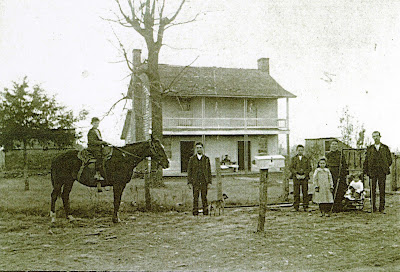 The date of the photo is circa 1904. (courtesy of Jessie Burney)
He remembers the property being located where the old Hwy 13 deadends in the new highway. No recollection of the house location or legal description.

Because we were able to find the remnants of both chimneys, they were massive over six foot at the base, I had Bill and Carl stand on them and then I backed up to approximate the old Burney photo. Which is what you see above.
Here is the chimney remnants.
In the above picture of the site you can't hardly see Bill and Carl but it gave me a marker for siting the house.
Here you have the ghost of the Evan's Station if you could see it today.

Here an old mechanized farm implement demonstrates the tenacity of a tree to grow. As a seedling it came up through this wheel. and just kept growing
 I also got some photos of the road nearby. I went to Helen Whites house and she gave me a tour of her Great Grandad's place which is near the Sac and has a well preserved section of the "old Boonville road" and the original ford where it crossed the Sac. The Murray place was built in 1878 but it was right on the road. Also found Alexander Evan's house. It is right on east side of FR141 and about a mile south of O road. It still stands and has been very well taken care of. They have added some funky white pillars to it but it was fun to see it.
This was a fantastic success to be able to find the chimney foot prints and really get a sense of how it looked.
